9/28/2011

A Trip Through Paradise (Part 2)

In Part 1 of this three-part series, we reached our camp on Circle Creek, set up our home-away-from-home for the next two nights, and settled in for some fun. I closed by introducing you to the key players. Now it's time to get on with the adventure.

The landscape keynote on this particular trip was Sphynx Mountain. Sphynx is, without doubt, the most noteable mountain in the Madison Range. While the entire range is made up of beautiful mountain peaks of various shapes and sizes, Sphynx must take the prize for most unique.

The Sawtooths (one mini-section of the extensive Madison Range) exude what makes a mountain majestic in my mind: jagged, rocky peaks. But Sphynx has captured my imagination from the first. Thus the opportunity to see this mountain from every angle, to examine it up close and personal, and to allow it to dominate my three-day trip - well, I couldn't have chosen an area I'd rather explore.

The day began bright and early. The night before had been warmer than I expected (I'd guess low to mid 40's). Thus it was easy to crawl out of my warm bed into an adventure filled day. After we filled our bellies, we saddled up. There was some discussion about the pack stock - leave them on the highline or take them along?? In the end, we decided caution was the better part of valor for, as you may recall, Molly was a great mule AS LONG AS she knew (or at least believed) she was not free. Once free - well, we knew we'd be taking a trip back to the trailer to find her should she escape the highline. So, Molly wore the soft-sided paniers with our lunch. Chance went unencumbered.

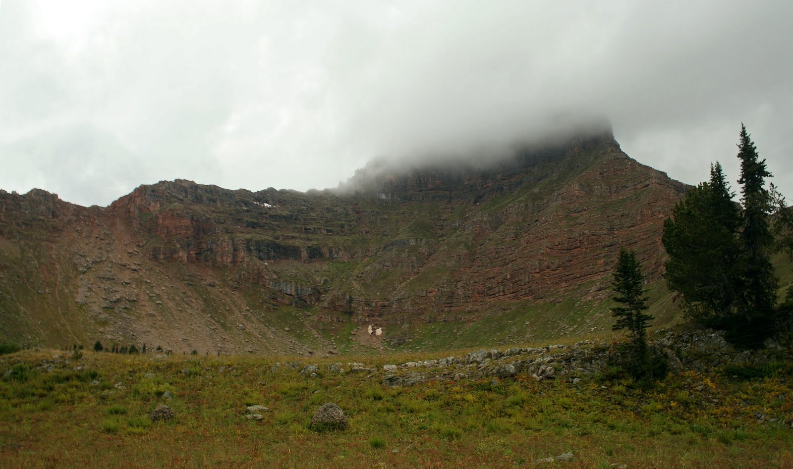
We picked up our trail where we'd left it yesterday to camp on Circle Creek. Today's route took us west (through the draw shown above), between Sphynx Mountain to our north and Circle Mountain to our south (shown to the right in this photo). The day's excitement started early. In addition to the bear tracks we'd followed to camp yesterday, early on we picked up some HUGE FRESH Grizzly tracks. Being in the lead, I kept my eyes on the trail, one leg on each side of the horse, and, as one elderly friend and horse trainer always said, "my mind in the middle." I must admit, I expected to meet that bear around every corner.

After about two miles we came to our first junction. In an adsolutely beautiful meadow nearby sat an outfitter's camp. A few tents scattered around. A few horses on the highline. And, no bear tracks in the trail. It looked like that particular bear was as shy of meeting people as this person was of meeting him. Boy was I glad!

A bit further up the trail we took our first break. Our hillside 'rest area' offered beautiful views back down the valley we'd just traversed and up toward Sphynx - the star of this particular show.

I was a bit surprised to find this sign tacked to the tree to which we secured our mounts (and pack animals). I did not expect to find an old stock driveway this far up the mountainside.

I never did learn the name of the mountain whose flank rose to our southwest as we descended to the next trail junction. However, it served as a distinct landmark displaying our progress.

After a brief rest for our trusty mounts and a few muscles stretches
for their riders, we were back in the saddle again. Since the whole trip
revolved around Sphynx, I was looking forward to more views of the mountain.

A bit further down the trail we crossed Bear Creek and junctioned into
the Bear Creek Loop trail. As our trail turned north-east up a lovely
draw, we gained our first glimpses of the day's high point (and I'm not
talking about Syphnx) - and it would definitely live up to that name!

After meandering through the lovely little draw our trail began to switchback up the pine covered hillside. Little did I know the day's excitement was just beginning. The first 'hint' came when the trail suddenly popped into the open and the ground seemed to disappear below my horse's nose as he made a sharp left turn. Once I put my heart back into my chest, I looked up to find Sphynx rising majestically to my right.

The scenery wasn't the only thing enhancing the day's adventure. Yesterday we'd ridden under a jewel-toned sky. Today's wind carried the sounds of change. Behind us a thunderstorm brewed while cold-grey clouds threatened liquid entertainment. And here were we - three fools headed for the highest point in the surrounding countryside!

While this section of the trail clung to the side of a steep tree-clad mountainside, ahead we could see Helmet standing sentry over a nice wide draw which offered a nearly level place to grab some lunch and give our mounts a break before the final climb.

I doubt anyone has ever enjoyed a prettier view out their cafe window. I'm not sure a prettier one exists. Certainly our animals were impressed - NOT! Heads down they filled their bellies while, heads up enjoying the view, we filled ours.

A striking mountain backdrop. A beautiful paint horse. A lush landscape. Like I said, this was a trip through paradise! (Our trail will be passing to the right of Helmet taking us over the saddle between it and Sphynx).

But back over our shoulders, storm clouds were closing in. If we were to finish this loop, it was time to get up and over that pass before they sent us on a hasty retreat.

Soon we were switch-backing our way up the last terrace to the saddle. While still a significant slope, thankfully this portion of the trail wasn't too steep - since we were approaching timberline with few trees to reduce the feeling of gliding through space. However, the lack of trees also meant in many places we were the tallest things on the slope. And, when you hear thunder, there is always lightening. Playing the role of 'sitting duck' on the back of my paint pony (even if it sounds like the start of a good western :-) just didn't appeal much!

The thunder rumbled - now nearly overhead. In the lead I approached the saddle. At lunch, Gail told me the last time they made this trip they walked their horses down the other side. However, he hoped, they may have worked on the trail a bit.

Well, from the top of the saddle, everything is DOWN - in nearly every direction. Unfortunately, only a short section of trail is visible from the top. So. . .as we reached the top Gail calls out to me (remember, I'm the leader - more like the blind leading the blind at this point) - "You decide whether we walk or ride."

"ME! I don't know the trail. You tell me."

"Nope, you're the leader. That's your job."

Well, that's what you get for taking a job without a written job description! In the end, Chief made the decision. He said, "I'm not playing lightening rod for one more second. Either you head me down off this fool's point or I'm making my own trail out of here."

So we plunged off the back side of Helmet - down a trail so scary I had to go back on foot (a few weeks later - that story might make it to the blog in the near future) to get the previous and next pictures - taken at leisure, at least in part due to the sunny skies.

To say it wasn't much of a trail is an understatement - at least for the first half-mile or so. The trail clung precariously to the north-east face of Helmet. The avalanche runs were little more than a collection of baseball- to football-sized round rocks looking for a reason to roll. The trail's best spots were not wide enough to see from my horse's back. Needless to say, I kept a leg on each side and my mind in the middle!

It was on our way down the 15 to 18 (I lost count somewhere down the line) switchbacks which dropped us into the next drainage that I discovered Red's one less-than-desirable trait. While I rode 'engine' on Chief, Burt rode 'Caboose' on Red. One of Chief's best traits is his willingness to walk right out - even down a ridiculously steep and narrow trail (and, to his credit, he never even stumbled - thank God, I think I'd have died of heart failure on the spot if he had!). Red, however, was ridden, as you will recall, by an admitted greenhorn. And, being old and wise, he already knew to take advantage of every advantage life throws your way.

So, while Chief strode on down that mountain, Red creeped. Naturally this increased the distance between the front and the back of our train. By the time we'd completed two or three switchbacks, Chief, Molly and I as well as Silky, Chance and Gail were already a level or two below Red. At this point, Gale called for a slow down for, he warned, were we to get much further ahead, Red would start taking short cuts - straight down the mountain!

Chief was not at all pleased with this turn of events. He had no desire to slow the pace! In fact, he wasn't opposed to picking it up a bit. So, this left us with only one option. Stop! I quickly learned to stop on the 'curve' of the switchback. Dancing feet weren't as scary with at least a nominal wide spot. And, as long as I was stopped, Silky was content to stop as well. And - - Red continued to plod down the hill, taking his own sweet time. Thus I enjoyed even more of the steepest section of this adventure than I'd hoped.

At the bottom of the mountain's face, we headed east toward Cougar Creek passing below Sphynx's brow to our south. Another four or five miles brought us to the final turn toward home. Heading south to south-west through the trees and down the meadows, this seemed easy. Little did I know there was one more adventure in store.

One more tight narrow spot - not as steep nor as high as the last 'adventure' - but this one held pretty little McAtee Creek and a slick-rock crossing followed by a BIG down tree on a steep hillside with almost no where to go. Thankfully there was just enough room - and on the uphill side - for the stock to squeeze by.

No, no pictures. The day had continued to darken as the thunderclouds rolled overhead. In fact, by the time we hit camp (about seven hours after we'd taken off that morning) it was hailing and raining and thundering. Thankfully we received a reprieve long enough to get the stock cared for and our own bellies full. By then, however, we were all content to head for drier and warmer quarters.

Lady of the Lake

9/21/2011

A Trip Through Paradise (Part 1)

Yellowstone Country is like a magical bag of delights. The more you pull out, the more it runs over with treats to be enjoyed. So, when I call this a "Trip Through Paradise", that is no exaggeration. The Greater Yellowstone Ecosystem is loaded with mini Shangri-Las, sometimes it seems a new one is tucked in every hidden canyon and over every tree-studded hillside.
However, this is no soft-palmed, easy-chair country. More often it abounds in aspects of the white-knuckled, strapped-to-a-rocket type of adventure. Certainly this was true of the horse packing trip I took this time last year. While many aspects were heaven-on-earth, every once in awhile I wondered if I'd morphed into some wild version of hell!
The trip began beautifully. Soon we were heading down the road - perhaps 'up' would be more appropriate as our route took us deeper and further into the mountains. From Hwy 191 north we turned west to follow Taylor Creek toward its source. The views of the Taylor Hilgards in the distance added a dramatic backdrop to our drive. Fresh snow sprinkled like powdered sugar on their peaks reminded us cooler weather had already descended in the high country.
The truck bed was full of packs and tack. A stock trailer loaded to its gills followed behind. The horses and mules knew the routine. They had taken this route before. I am certain, the sights and sounds we traversed that morning were familiar to them. However, to my unenlightened eyes, breath-taking new vistas seemed to magically appear before my eyes.
My host was well versed in this country having traveled much of it on horseback and snowmobile. Thus, without doubt, I have forgotten more imparted knowledge than I have retained. Nonetheless I relished the beauty and the dialogue as we traveled past such beautiful valleys as this one which, if traveled, would eventually drop me back down on the shores of Hebgen Lake. After about 30 minutes following Taylor Creek, we turned onto a spur road and climbed a steep and bumpy road toward the Cache Creek Trailhead.
Traveling Montana's mountain back roads with a trailer is often a time-consuming experience. While I learned the road to our destination had seen much improvement, it still took nearly an hour to cover the several miles of gravel from the highway to our trailhead. Once there, however, the real work began - for us and our stock. Unloading finished; loading commenced. Chance, the yellow mule in the foreground (the photogenic clown of the group) was the young pup. True to age, he acted the part. Thus it took awhile to get him loaded! Once his pack was securely fastened, we tackled the rest of the crew. Soon everything was strapped on.
After a quick lunch which gave our stock time to settle into their gear, we hit the trail. We were headed for Circle Creek via Indian Crossing. Thus our journey began with a long, steady climb from our trailhead to a beautiful plateau. A steady climb is a blessing when one is dealing with fresh stock who have spent far too few days under saddle recently. Thus, as we switchbacked our way up the side of the mountain, our stock (and their riders) worked out some of their kinks.
As we neared the top (of the ridge which divides the Madison and Gallatin drainages), we had a great view of the valley we had traversed to reach our launching point. With sunshine on our shoulders, a warm breeze in our faces, and beautiful vistas in every direction, our trip could not have begun on a better note.
Once at the top, I became the groups unofficial leader (a position I would retain throughout the trip's remainder). Our trail now worked its way down a mild draw which dumped us into the headwaters of Indian Creek. Here, along the creek's beautiful upper regions, we picked up the day-old (ish) tracks of a large grizzly. We followed these 'local resident' reminders all the way to Circle Creek and our new home-away-from-home for the next two nights.
As we set up camp, my generous host regaled me with stories of the big Grizzly who charged their camp repeatedly the prior hunting season. I set up my tent a discreet distance from the 'guy's quarters' pondering whether I was, perhaps, closer to the potential Grizzly path into camp or further. I decided it mattered little if the Griz was intent on a few human sandwiches!
Night comes quickly to the high mountains. By the time we reached our campsight, we had consumed much of the afternoon. Thus once our tents were erected, we went right to work setting up the rest of the camp. The official 'campfire builder' worked his magic. I helped our host care for the stock (which we allowed to graze until they started looking back down the trail - at which time we secured them to the highline for the evening).
After supper we strolled up Circle Creek a few hundred yards to the next little meadow and enjoyed a few more wild stories by the campfire to fuel my dreams. I even had time to journal my day's experience before I crawled into my cozy bed - bear spray by my side and ear plugs in my ears (I certainly did not want to jump at every sound all night long!). I must admit, I slept like a baby.
Before I continue, I need to introduce you to the key players in this 'over-the-top' adventure. This is Gale, my host, our guide and the owner of the stock which took this journey from an idea to a reality. Gale has spent many many hours in this country - hunting and recreating. Thus he not only knows the area, he has a plethora of stories to share (some, perhaps, I could have done without hearing)!
Burt, the second member of our party, is an admitted greenhorn who hails from New York but spends several months each winter in West Yellowstone. More at home on a snowmobile (when it comes to backcountry winter excursions I don't know anyone I'd rather have in the lead) than a horse's back, Burt was a good sport who never complained - regardless of the long days and narrow trails. Since horse's weren't his 'thing', he took the role of official fire-starter / tender - a job at which he excelled.
I have already introduced Chance, the resident 'teenager'. Two more mules and two horses rounded out our transportation. Silky can be packed or ridden. According to Gale, she offers a smoother ride than any horse he's ridden. I can't speak from experience, but I can say she still acts like a mule. If Silky doesn't want to go there - you ain't going! Nonetheless, I never saw her take a false step, nor did she act ruffled (well, except for one time which, compared to everything else, really didn't matter) regardless of what came our way.
Chief was 'horse extra-ordinare'! Granted, he had to learn I was the boss - but once we'd worked out that little detail, he carried me over many miles and through a few hair-raising experiences. He made a fine lead horse willing to move ahead into the unknown - even when I wondered whether the better course of action might have been to forego this section of trail.
Then there was Molly, the third mule in our string. From our introduction in her home field, through the balance of our time together, I came to respect Molly as a dependable, sturdy, fuss-free creature who would work without complaint ONCE SHE WAS CAUGHT! Knowing this particular foible in her otherwise perfect character, I kept a tight hold on her lead whenever she was in my care (which turned out to be most of the trip).
Red rounded out the crew. The 'old man' of the group, Red was steady and patient with only one quirk - one which I learned about at a fairly inopportune time (see the next post). However, he caused no rucus, created no problem, and took his rider, Burt, safely from beginning to end. One just couldn't help but like ole' Red.
The adventure has just begun. Now that I've introduced you to everyone and interspersed a few hints of things to come, I hope you'll come back to read the rest of this wonderful adventure - truly a major highlight in my life here at Elk Lake Resort!
Lady of the Lake

9/09/2011

A Visit To Sheep Lake (Part 2)

After posting Part One, I realized I did not share the location of my new favorite lake. Sheep Lake is nestled beneath Coffin Mountain's overhanging brow. While it is shown on the Lee Metcalf Wilderness map - an area which encompasses much to the west of Yellowstone National Park; is located only about 20 miles from Elk Lake (as the crow flies - but only the crow travels straight in this mountainous country); and is in Montana (never a given around here), I am not certain to which mountains it belongs. Is it in the Lionshead mountains? The Henry's Lake Mountains? The beginning of the Madison Range? All three intersect near Raynolds Pass where one finds Sheep Lake's trailhead.
The golden sun beamed from a robin's egg sky. Our trail wandered from meadow to meadow then along a rock-strewn hillside as we worked our way ever forward, ever upward.
Last year (another one of those hikes I see I failed to write about - definitely a must-do for the near future) Lesli (a summer helper and a great hiking companion), the kids, and I made another trek - to the other side of the mountain (literally). If we had the time - and the energy of the 9-year-old - we could have traveled across a 'divide' and dropped into the Sheep Lake Trail. In fact, for a one or two day overnight backpacking excursion, it would be fun to park a vehicle at each trailhead and explore the country between the two lakes.
The map showed the junction. We looked for it, but not seriously as we were not planning to head that direction. I'm just glad we did not have to find this junction to reach our intended destination because, it is WELL HIDDEN! In fact, when the USFS horseback team finally reached Sheep Lake, I asked them about the trail junction. They responded: We discussed how difficult the sign is to spot on our way up today. And, it was difficult. While we might have spotted it if we had not been watching our step on the rocky trail, I'm not certain. The trail jutted off at a sharp angle to our left, nearly parallel the trail we were hiking and in a seemingly unlikely location. The trail sign (which we nearly missed although we were looking carefully on our way back) had fallen over and was nearly overgrown by the surrounding short but heavy foliage. All-in-all, unless they fix the sign (and the crew we met were doing trail work but had left this sign lay so. . .), if you plan to make the loop, be aware the junction is difficult to spot, especially if you are heading up the hill.
As we gained elevation, the view back down the valley we had traversed began to open up. The Madisons rose majestically in the distance while the rocky hillsides in the foreground rallied 'round their snow-capped cousins.
It seems the trail's designers wanted to make sure any visitors were seriously motivated. While the majority of the trail is nicely graded with a steady but not steep climb, the last section was quite steep. At this point, the most challenging part was not knowing how long we would have to climb - and how many more climbs were awaiting us after we tackled this one.
The dusty, rocky climb dumped us at the foot of a charming little 'park'. A slow moving stream meandered through its center. Beautiful fish drifted lazily just under the water's surface. The surrounding mountains embraced this emerald valley while Coffin Mountain sat like a king enthrowned at its head.
The castle rocks looming over our shoulders further enhanced the 'royal'
impression. With ease we could imagine ourselves tucked away in a fairy
kingdom with castle walls and giant mountains. Further down the valley
we had even spotted what looked like a giant rock chair perched high on
the mountain side.
Maybe it is a good thing we were nearing our destination. Maybe all that fresh air and healthy exertion had gone to our heads. Maybe in another mile or so, we would have convinced ourselves our mountain kingdom was more real than the world we'd left below. Perhaps we were spared further delusion. Regardless, we were very happy to see what appeared to be a small rock dam just ahead. And, it was a dam of sorts, although I've never seen a high mountain lake with a man-made dam at its foot.
No doubt about it. Sheep Lake is a watery jewel tucked high in a rugged
landscape. Coffin Mountain looms ahead - the ever protective uncle. Rocky
arms encircle the lake with a posessive air. Beautiful fish work the shoreline
flashing their colors up through the clear waters.
Only at the foot, back toward the creek outlet and the little rock dam, do the mountains relax their guardianship enough to allow the lake to trickle through their fingers into the valleys below.
The time had come to rest our feet and fill our tanks. With relief we settled down on the warm rocks to enjoy a lunch of fresh baked sourdough bread, grilled chicken, fresh veggie strips, Cliff Bars, nuts, and cool water. Ahhh - lunch in paradise!
It was amazing the way the elements came together on this hike to provide an almost unearthly feeling. The castle-wall mountains. The lush, rich setting. The giant 'throne'. The brilliant and abundant wildflowers. A 'cultured' setting the rival to even the finest 'designer' garden. Even the rocks glowed and glistened as if they were drenched in precious metals.
About half-an-hour after we'd reached the lake, in rode the USFS trail crew. As we'd hiked the trail ahead of them, we knew they had only had to deal with one log in the trail. I suspect they stopped to discuss things like swampy areas and nearly invisible trail signs, but their amazement nearly matched our own. They did NOT expect us to beat them to the lake. We didn't expect to beat them, either - especially by such a margin. Nonetheless, as we pulled our packs back onto our trail-weary bodies, it was a bit energizing to realize we were facing the down-hill part and to know we'd already proven ourselves more than competent hikers.
Down. Down. Down. We worked our way back through the meadows, across the rock-strewn hillsides, down the several switchbacks, back through the open timber, and found ourselves once again deep in the tall, thick brush. Moments later we popped out in the lower section - the upper Madison valley at our feet.
The end! We made it! All the way up and back with no injuries and TONS of memories.
The hike up took us about 3 hours with just a few brief water stops. The trail back took about the same time, but we spent about 30 minutes picking a few of Montana's special treasure - huckleberries! Yumm - Huckleberry Pancakes, here we come!
Lady of the Lake

9/03/2011

A Visit To Sheep Lake (Part 1)

For several years I have wanted to hike into Sheep Lake - ever since some horseback riders from Virginia hauled their horses all the way to Montana just to ride in our mountains. After they shared photos from their trip into this country, I was hooked.

For the last two years it has been on my to-do list. This year I finally had the chance to do it - so, with my faithful hiking buddies, I headed for the trail. As we were loading up our packs and preparing to head off, a USFS crew began unloading their horses. We thought we might see them again (actually we thought they would pass us on the way up - thus I will brag on my crew because THEY DIDN'T). Great hiking guys!

I have learned any time you head up "----" Creek Trail (whatever creek it may be), you can be sure you will cross water - probably several times. After my experiences last year (for example hiking the Odell Creek Trail), I have come to expect anything from slippery logs to stob-studded booby traps to good bridges. Thus trail, however, turned out better than most, with good bridges. . .


Most of the time! Why the USFS had bridges over every stream crossing but the second one - I do not know. On our way back the logs were dry and the crossing easy. On our way out that morning (when we definitely did NOT want wet feet) the logs were wet and slick. Thankfully no one fell in.

We had enjoyed a leasurely morning yet we were blessed with a comfortable hike - cool enough yet warm enough. The bugs weren't too bad and the day was absolutely gorgeous. Put all that together with some great hiking companions and a drop-dead-gorgeous setting and. . .we were hiking in paradise!

The lower section of the trail turned my mind to bears! The lush creekside provided the perfect environment for a jungle which often grew higher than our heads (yes - there are people in this picture - look closely at the middle of the photo). Thimbleberries. Gooseberries. Huckleberries. Raspberries. Currants. And more provided what looked to me to be the 'perfect' bear haven. Thus we kept the bear spray ready and corraled the youngest (and most energetic) member of the party in the middle of the pack (much to his chagrin).


Sheep Creek is a beautiful creek which offers many photo opportunities in spite of the heavy undergrowth. In fact, while our path often took us far from its banks, its delightful rumble and rush were rarely out of earshot.

After about a half-an-hour, our trail began to climb away from the lush creek bottom. It wound its way through an open forest. Oddly enough, even though the trail did return, at times, to the creek's bank, the heavy undergrowth did not return. (Note the youngest hiker. This is the one the horseback riders thought would slow us down - probably because he has the shortest legs. Yet, if you look closely, you will see he is not only keeping up, he even has the energy to stop regularly and pitch a few rocks - which means, of course, he has to run faster and farther to catch back up. Why, oh why, does he get all the extra energy?)


All that running and throwing did make him thirsty, however. This shady spot seemed the perfect spot to grab a drink, rest our legs (or not), and take a breather (always expecting to see the horseback riders coming around the bend). Soon, however, we were back on the trail.


About forty-five minutes into our hike the forest began to give way to rocks. Rocky Screes. Rock Slides. Big Beautiful Brazen Rocks. Rocks which tempted us to take a closer look - but not enough to get us off the trail.


However, the youngest hiker (with the shortest legs - who'd been doing the most running already) had to do a little climbing - PLEASE MOM! So, a couple minutes were allotted to climbing one big rock and then a quick photo shoot then hit the trail kid!


About fifteen minutes later we crossed the creek once again and began switch-backing our way up the mountainside. I will say this trail is nicely laid out. It is wide and level and even offers decent grading on most of the climbs.


The switchbacks landed us in a lovely meadow. For the most part, the rest of our trail traversed through a series of high mountain meadows, always gaining elevation as it proceeded to our destination.


One last time we crossed Sheep Creek. From this point onward we would pretty much follow the creek (at a distance) to its source.


Did I mention this hike was GORGEOUS! All of the hike was pretty, but once we popped out into the open meadows, the scenery became stellar. Rocky mountains buttressed 'round our meadows, bulking large on each side of our trail.


Up, Up, Up we wound - following the winding trail past stands of timber and across grassy fields. Rough rocky crags drew our eyes upwards. Puffy white clouds adorned an azure sky.


And wildflowers lined our pathway by the thousands. Boulder-strewn hillsides showed a rougher side, but the posies softened the picture. A LOT! In fact, there were many spots (like the one shown above) where I couldn't help but think of glossy magazine photographs depicting cultured yards upon which thousands of dollars had been spent trying to achieve something this gorgeous! Yet, in the Creator's garden, the harsh and the gentle are mated to create beauty beyond words (and beyond imitation).


Even surrounded by such beauty we were starting to wonder if Sheep Lake really existed. Our trail continued to meander through the meadows. The creek continued to gurgle and giggle by our side. Around each corner another breathtaking vista appeared. But where was the lake? Little did I know at the foot of that mountain in the distance (the one with the snow) lay that sparkling gem. Join me next time as we reach our destination.

Lady of the Lake